An Air New Zealand Q300 and a Beech 76 Duchess ZK-JED were on reciprocal tracks when a close proximity event occurred, requiring avoiding action.
Executive summary Tuhinga whakarāpopoto
What happened
- On 28 August 2023 at about 0945, an Air New Zealand Q-300 aircraft, registration ZK‑NES (the Q-300), was preparing to depart Whangārei for Auckland. At the same time, a light twin, a Beech 76 Duchess with registration ZK-JED (the Beech) was tracking north in controlled airspace towards Whangārei from Ardmore at 7000 feet (ft). They were both flying under Instrument Flight Rules (IFR) and would be following standard flight routes in reciprocal directions.
- The timing of these two flights meant that they would need to pass each other somewhere along the route segment Q520. The air traffic controller managed their respective clearances to enter or leave controlled airspace so that the two aircraft would pass each other in uncontrolled airspace. This was common practice for the air traffic control unit and meant that air traffic control was not responsible for collision avoidance, placing that responsibility on the pilots.
- Once outside controlled airspace, the two flight crews relied on two sources of information to maintain awareness of their position in relation to the flight path of the other aircraft. These were traffic information provided by air traffic services and radio communication with the other aircraft. Additionally, the Q-300 had an Airborne Collision Avoidance System (ACAS) fitted that helped them know where other aircraft were in relation to their flight path. The Q-300 flight crew became aware of the conflict from the display on their ACAS and were preparing to take action to avoid a collision.
- The air traffic service did not provide the respective flight crews with updated traffic information about the other aircraft. Such information would have allowed them to be aware of the nature and timing of their conflicting flight paths, and to then manage their own separation.
- The air traffic controller and an instructor sitting with them were monitoring the conflict outside their jurisdiction on their surveillance radar display. The instructor noted the potential for collision. They suggested a method for resolving the conflict by offering the Q-300 clearance to climb into controlled airspace. This was immediately applied by the controller.
- The aircraft passed each other in close proximity while in cloud and could not have physically seen each other. The Q-300’s ACAS detected a traffic alert condition. The air traffic control system also detected that the two aircraft were close and raised a Short-Term Conflict Alert to the controller.
- There was no damage or injuries.
Why it happened
- This incident occurred because the two flight crews were in uncontrolled airspace and did not have sufficient, up-to-date traffic information from the air traffic controller or flight service officer about the immediacy of a potential conflict, in time for them to coordinate their own avoidance actions.
What we can learn
- The Commission found that it was common practice for the air traffic control unit within Airways to direct IFR traffic south of Whangārei to pass in uncontrolled airspace, and for the flight crews to manage any potential conflict themselves.
- The Commission also found that the airspace around Whangārei had not been reviewed since 2014. In 2025, it was still not scheduled for review by the Civil Aviation Authority (CAA), despite the required review period being at least every five years. This delay was due to a change in the CAA’s approach to airspace review. However, in the meantime, multiple safety concerns about the airspace had been identified by pilots, air traffic controllers and the aerodrome operator, that remained unresolved.
- The current Civil Aviation Rule (CAR) Part 71 Designation and classification of airspace, that defines the scope and frequency of airspace reviews, was amended in 2008. It has since been updated to reference the new Civil Aviation Act 2023, but remains substantially the same. CAR Part 71 is confined to only consider if the current airspace designations and classifications are still required. However, more comprehensive airspace reviews are necessary to ensure that the airspace design is appropriate and effective, and that it achieves an acceptable level of safety for all users.
- In 2023, a government-led Air Navigation System review identified the growing demand on airspace from new technologies, as well as new disruptive forces (examples of disruptions were new airspace users such as drones, unmanned transport vehicles and space craft). The review also identified the need for greater system leadership at a state level and improved accountability for system performance.
- The Commission made two safety recommendations to resolve the safety issues: one to the CAA to conduct a comprehensive airspace review for the Whangārei area, and one to the Ministry of Transport to address the current gaps in the Civil Aviation Rules relating to airspace reviews.
Who may benefit
- All aviation participants may benefit from the findings and recommendations in this report.
Factual information Pārongo pono
Background
- This incident occurred when two aircraft flying in cloud under Instrument Flight Rules (IFR) passed each other in close proximity. Circumstances of this air proximity incident are explained below. Information provided in Appendices 1 and 2 may assist readers unfamiliar with the terms and airspace described in this report.
- The aircraft involved were:
- a southbound Air New Zealand-operated Q-300 (while the Q-300 is now more correctly called the DHC Dash-8-300, this report refers to the aircraft as a Q-300 in keeping with the nomenclature used by Air New Zealand) (registration ZK-NES), operating as flight number NZ8221, call sign ANZ221L (the Q-300)
- a northbound light twin, Beech 76 Duchess (registration ZK-JED) (the Beech)
- A detailed timeline of the incident is provided in Appendix 5.
- At the time of the incident, several aircraft were being controlled by the North Sector controller (the controller). The controller was accompanied on the day by an instructor. These aircraft were (see Figure 3):
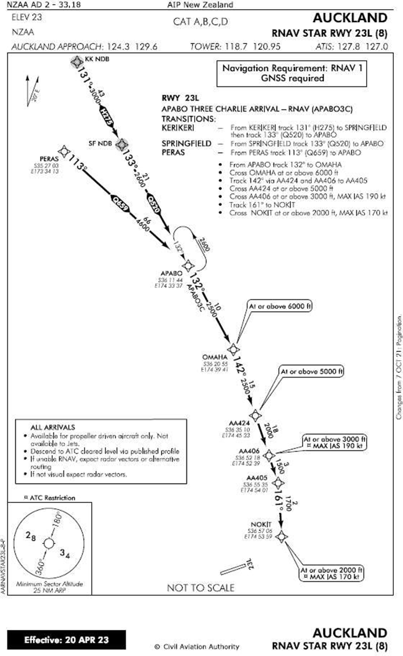
- the Q-300 at Whangārei, preparing to use the Standard Arrival Route (STAR) APABO-3C to Auckland at 12,000 feet (ft)
- the Beech, approaching Whangārei from south of APABO at 7000 ft to then follow route segment Q520 to SPRINGFIELD
- a Kerikeri Q-300 flight preparing to use the same STAR as the incident Q-300, into Auckland at 16,000 ft
- a Cessna 208 heading south to APABO at 10,000 ft along route segment Q659.
Narrative
- On 28 August 2023 at about 0940 (times are stated in New Zealand Standard Time (NZST), which is Universal Time Coordinated (UTC) + 12 hours), the Q-300 was preparing to depart from Whangārei to head south to Auckland. At the same time, the Beech was tracking north towards Whangārei from Ardmore at 7000 ft (note that in New Zealand, in accordance with exceptions to the International System of Units and with the Aeronautical Information Publication (AIP) Gen 2.1, altitudes, elevations and heights are measured in feet. In this report these parameters are therefore only expressed in feet (ft) without a metric equivalent). They were both flying under IFR and planned to follow standard published flight routes (a flight route is a horizontal line on an aeronautical map between two or more points. It is analogous to a surface transport highway shown on a land map).
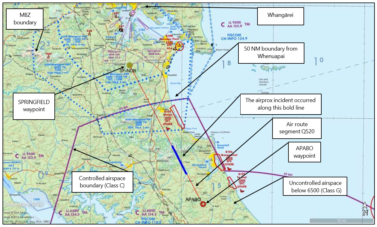
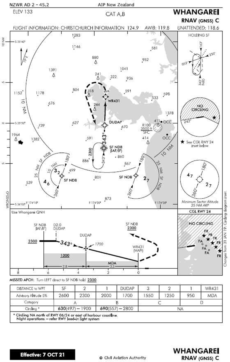
- The Q-300 had planned to follow STAR APABO-3C to Auckland. It would join at SPRINGFIELD, follow route segment Q520 south to APABO (these are listed in the International Civil Aviation Organisation (ICAO) waypoint database as APABO and SF) then continue south to Auckland.
- The Beech was on standard flight route ARWR1 from Ardmore to Whangārei. ARWR1 passed APABO and followed route segment Q520 north to SPRINGFIELD. At SPRNGFIELD, they planned to enter a holding pattern before following a standard instrument procedure for their approach to land at Whangārei.
- This meant that for a period, both aircraft would be following the same 20 nautical mile (NM) (nautical mile is the unit of measure used in aviation: 1 NM = 1.852 kilometres) route segment (Q520) in opposite directions. They would need to cross paths at some point with assistance or guidance from the controller (see Figure 4 and Appendix 1 for a larger scale view).
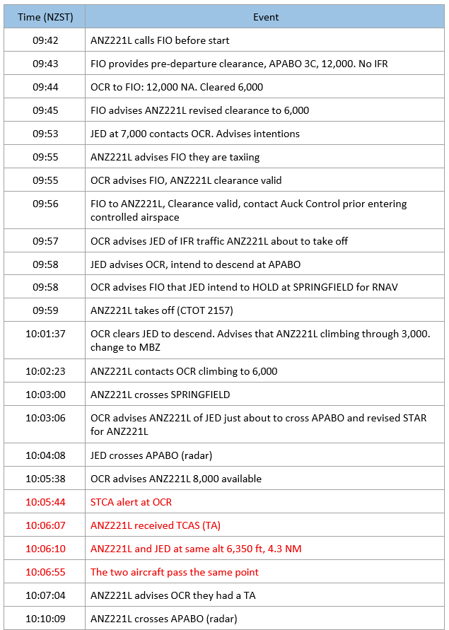
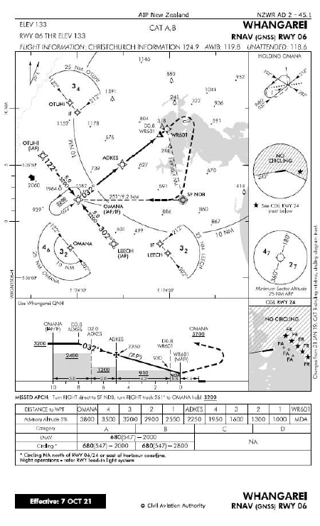
- At 0942, the Q-300 contacted the Flight Information Officer (FIO) for clearance to climb into controlled airspace. (Whangārei airport is uncontrolled, so aircraft contact the FIO to request clearance to climb into controlled airspace. The general IFR procedures at Whangārei are explained further from paragraph A2.39). The FIO responded at 0943 with pre‑departure clearance for STAR APABO-3C at 12,000 ft. They advised that there was no IFR traffic (this meant that there was no IFR traffic within 10 minutes flying time) but also that their clearance had yet to be validated (accepted by the controller and confirmed). The Q‑300 was to remain outside controlled airspace and report again when they were taxiing.
- At 0953, the Beech contacted the controller as they approached APABO from the south at 7000 ft. The controller asked what their intentions were. The Beech responded that they planned to conduct a standard holding pattern at SPRINGFIELD, then follow the RNAV-C approach to Whangārei (RNAV is a standard area navigation procedure, and the designation ‘C’ indicates one of multiple route options to Whangārei).
- At 0955, the Q-300 advised the FIO they were taxiing and were told to stand by for a clearance validation. The FIO then phoned the controller who confirmed the clearance was valid, but with a 6000 ft altitude restriction that meant they must remain outside controlled airspace. The FIO relayed that information to the Q‑300 at 0956.
- At 0957, the controller called the Beech to advise them of nearby IFR traffic: the Q‑300 that was about to take off and climb to 6000 ft for Auckland.
- The controller then phoned the FIO to advise the Beech pilot’s intentions. At 0958, while the controller was still on the phone to the FIO, the Beech radioed the controller to advise that they planned to descend from APABO. They repeated the message as the controller did not respond to the first message. The controller completed their phone call with the FIO and acknowledged the Beech’s message.
- At 0959, the Q-300 took off from Whangārei with the captain as pilot flying and the first officer as pilot monitoring and operating the radios.
-
At 1001, the controller contacted the Beech and cleared them to descend. They updated the earlier traffic information relating to the Q-300, stating:
JULIETT ECHO DELTA cleared to leave controlled airspace via descent the Dash Eight has just gotten airborne from Whangārei passing through THREE-THOUSAND-ONE-HUNDRED FEET unverified, continue with local ONE-ONE-EIGHT Decimal SIX (the local Mandatory Broadcast Zone (MBZ) frequency) and contact Christchurch Information (where the Beech descended, CH INFO was on 118.5 then later as they progressed north of Waipu it changed to 124.9) for further.
- At this time, the controller had arranged for the Q-300 to maintain 6000 ft and the Beech to descend through that altitude. This was outside controlled airspace and on a reciprocal heading along route segment Q520.
- At 1002, the Q-300 contacted the controller to tell them they were climbing to 6000 ft. The controller identified them on radar and correlated their radar target with their flight plan. The controller withheld clearance to enter controlled airspace and advised them to remain at 6000 ft (below controlled airspace) and to expect a radar climb (the instruction to ‘expect a radar climb’ means that the controller would advise when there was no conflicting traffic for them to climb into controlled airspace). The controller also informed the Q-300 of a change with the STAR in their clearance to Auckland. The revised clearance was along the APABO-3A STAR (this was the same routing to APABO as the previous STAR but had an extension further south near the Auckland Aerodrome). The flight crew then reprogrammed the flight management computer with the revised STAR.
-
At 1003, the Q-300 passed over the SPRINGFIELD waypoint. A few seconds later, the controller advised the Q-300 of traffic information about the Beech:
And traffic affecting further climb is a Beech JULIETT ECHO DELTA, just about to cross APABO northbound for Whangārei shortly leaving controlled airspace via descent.
-
The Q-300 flight crew were occupied with post-take-off and climb actions and reprogramming the flight management computer when the Beech made their broadcast on the Mandatory Broadcast Zone (MBZ) (an MBZ is a volume of uncontrolled airspace where all pilots must operate on the nominated frequency to regularly report their position and intentions; see Appendix 2, paragraph A2.17. for more information) frequency a few seconds later:
Whangārei traffic, JULIETT ECHO DELTA, 2 miles south of APABO at 7000 feet. Descending shortly for RNAV-Charlie Whangārei (source: ZK-NES cockpit voice recorder).
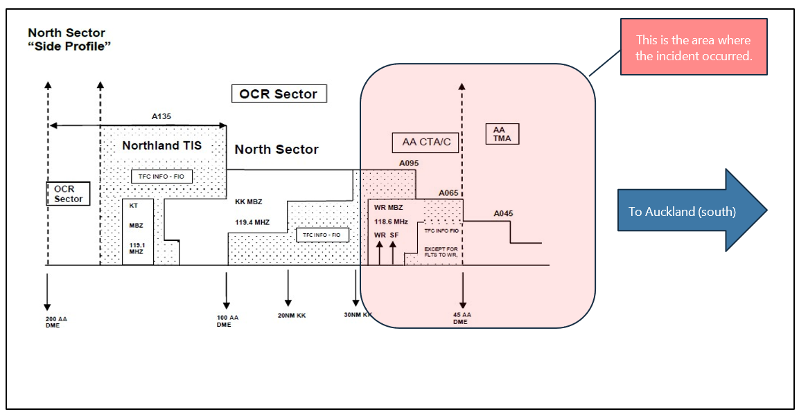
- At 1004, the Beech passed over APABO at 7000 ft and started to descend. At the same time, the Q-300 was south of SPRINGFIELD at 6000 ft. Both aircraft were following route segment Q520 on reciprocal headings. As both aircraft were in uncontrolled airspace but near to the MBZ boundary, they were listening on the MBZ frequency (see Figure 5 for the airspace boundaries near the incident area and see Figure 6 for the airspace profile).
- At 1005, during their normal instrument scan, the Q-300 flight crew noticed the Beech appear as a conflicting target on their Traffic Collision Avoidance System (TCAS) (TCAS is an aircraft system which provides the pilot guidance on potentially conflicting aircraft that are transponder equipped. See Appendix 3 for further explanation of airborne collision avoidance systems (ACAS) and TCAS features and aircraft instrument displays) display. The Beech was directly ahead at approximately 12 NM and 800 ft above, but descending towards them. Ten seconds later, the Q-300 captain took over the radio and called the Beech on the MBZ frequency, asking if they were descending. The Beech responded that they were descending to 2600 ft. The Q-300 captain asked for their altitude, and the Beech responded that they were passing 6500 ft (that was the lower limit of controlled airspace in the area).
- Meanwhile, the controller was monitoring the two aircraft in uncontrolled airspace, approaching head-on along route segment Q520. The instructor suggested to the controller that they clear the Q-300 to 8000 ft. The controller’s radar then displayed a Short-Term Conflict Alert (STCA) at 1005:44 (displayed as CA on the radar display) (see Figure 7).
- The radar display shows a predicted leader line that represents where the aircraft will be in three minutes, based upon its current airspeed and direction. When the leader line is red, this indicates that the aircraft is in a conflict situation. Green text indicates that the aircraft are within the controller’s sector.
- Within seconds of the STCA, the controller offered the Q-300 their expected radar climb to an initial 8000 ft. The captain immediately accepted and initiated a climb.
- The Q-300’s TCAS then advised the flight crew of a near-proximity event with an audible warning: ‘TRAFFIC, TRAFFIC’.
- The Beech called the Q-300 to further coordinate their pass, but the Q-300 flight crew were busy monitoring their level change and did not respond. There were no further radio conversations between the two aircraft until they had passed each other, and the Q-300 was at 8000 ft in controlled airspace.
- As the Q-300 levelled off at 8000 ft, the captain called the controller and advised they had received a traffic alert off the Beech. The controller acknowledged the message.
- The Beech then called the Q-300 again on the MBZ frequency to coordinate their passing. The Q-300 captain responded that they were clear of the Beech’s position but had received a TCAS traffic alert off them.
- At 1006:10, the two aircraft passed through the same altitude in uncontrolled airspace, at 6350 ft and 4.3 NM apart but with increasing vertical separation. At their combined closing speed of approximately 378 kt, they were 41 seconds apart at the closest point (see Figure 6 for a side view of the flight paths).
- As the TCAS event occurred outside controlled airspace, the controller did not regard it as a reportable incident. The operator, Air New Zealand, reported the incident to the Civil Aviation Authority (CAA) who then reported it to the Commission on 28 August 2023. The Beech pilots were unaware that they had experienced an air proximity event until they were advised afterwards by the captain of the Q-300, and they did not report it.
Personnel information
Q-300 flight crew
- The Q-300 had a flight crew of two: a captain and a first officer. The flight was a regular scheduled passenger flight, operated by Air New Zealand, with 40 people on board.
- The Q-300 captain had an Airline Transport Pilot Licence (aeroplane) (ATPL) issued in 2021 with about 2,800 hours flying experience. They had gained their command about 12 months before this incident and been with the operator since 2019. They had a Category C instructor rating and an instrument rating. During the previous 30 days, they had logged 30 hours as pilot in command in Q-300 aircraft.
- The Q-300 first officer had a Commercial Pilot Licence (CPL) issued in 2017 with about 1700 hours flying experience and had been with the operator since 2022. They had about 214 hours on the Q-300, with 37 hours in the last month.
The Beech
- The Beech was on a private IFR training flight from Ardmore to Whangārei, return, with two people on board. It was a practice instrument flight for the pilot flying, with the instructor as pilot in command. The return leg was intended as a test for the pilot flying’s instrument rating renewal.
- The instructor had an ATPL issued in 2006 and about 14,950 hours flying experience. They had ratings on the Airbus A320, Boeing 777 and 787, and the Beech 76. They had a B and D Category instructor rating that included night, IFR and multi-engine rating, and a Part 135 flight examiner rating.
- The Beech’s pilot flying had a CPL that was issued in 2021 and about 315 hours flying experience. They had an instrument rating.
Flight Information Service
- The Flight Information Service (FIS) for Whangārei was provided from the Christchurch Air Traffic Control (ATC) centre. Normally the FIO desk would have a planner supporting the FIO, but at the time of the incident traffic density was low, so the FIO was operating the desk alone. An FIO monitors several flight information regions for New Zealand at one time.
North Sector air traffic controller and instructor
- The controller was an appropriately licensed person undergoing conversion training at the time of the incident. It was their second day of live training under an instructor. Both the controller and the instructor stated they were wearing headsets with microphones.
- The controller had more than 20 years controlling experience. In 2020 they spent two years in a managerial role. At the time of the incident, they were part-way through their six-month conversion and currency training to return to an operational role.
- The instructor had more than 15 years controlling experience and had worked on the North Sector for more than five years. They held an air traffic controller licence, had ratings validated for the operating position and were current in the role. They held an Air Traffic Service (ATS) Instructor rating for on-the-job training.
Meteorological information
- The MetService weather forecast for the incident area was for broken cloud with bases around 2000 to 3000 ft, and tops from 8000 ft to above 10,000 ft. Visibility was expected to be 20 km in clear air and the freezing level at 4000 ft. Wind was 5 knots (kt) from 330 degrees true.
- The forecast air pressure at Whangārei had it rising from 1016 hectopascals (hPa) (Hectopascal (hPa) is a unit of barometric pressure at a datum, set on an altimeter to determine the aircraft’s altitude, the datum being sea level) to a maximum of 1025 hPa, and the forecast 2000 ft wind was 15 kt from 220 degrees true
- When interviewed, the pilots said that it was a fine day, but there was a solid layer of cloud from about 4000 ft to about 6500 ft near where the incident occurred.
Recorded data
- The Commission obtained electronic recordings of:
- air traffic control radar plots
- air traffic control and flight information service radio and telephone conversations
- Whangārei Aerodrome radio recordings for the MBZ
- Automatic Dependent Surveillance-Broadcast (ADS-B) data from Airways.
- The Commission obtained the Q-300 digital flight data recorder and cockpit voice recorder. It was assisted by the Australian Transport Safety Bureau (ATSB) to download and interpret these files.
- The Beech did not have a flight data or voice recorder, and it was not required to do so.
Analysis Tātaritanga
Introduction
-
An aircraft air proximity (airprox) (The International Civil Aviation Organization (ICAO) and the Commercial Aviation Safety Team (CAST), which includes government officials and aviation industry leaders, have jointly chartered the CAST/ICAO Common Taxonomy Team (CICTT) to develop common taxonomies and definitions for aviation accident and incident reporting systems) incident is defined by the International Civil Aviation Organization (ICAO) (ICAO Doc 4444: PANS-ATM, definitions) as:
A situation in which, in the opinion of a pilot or a controller, the distance between aircraft, as well as their relative positions and speed, was such that the safety of the aircraft involved was, or may have been, compromised.
Airprox incidents can be significant indicators of wider and more serious safety concerns.
- Under Annex 19 – Safety Management (this is one of the annexes to the Convention on International Civil Aviation), each member state of ICAO is expected to implement their own State Safety Programme (SSP). The New Zealand SSP (this refers to the SSP dated January 2018 applicable at the time of this incident. It was revised in 2025) details ‘airborne conflict’, which includes airprox incidents, as one of eight safety and security focus areas that need to be mitigated to improve the aviation system. The SSP requires mitigations to achieve an ‘acceptable level of safety performance’ (ICAO Annex 19-Safety Management and ICAO Doc 9859-Safety Management Manual)
- The following section analyses the circumstances surrounding the incident, and identifies factors that increased the likelihood of the incident occurring or increased the potential severity of its outcome. It also examines any safety issues that could adversely affect future operations.
Three perspectives: Why the airprox incident happened
The controller’s perspective
- In the controlled airspace between Whangārei and Wellsford, the controller had four aircraft to manage: a southbound Cessna 208 (at 10,000 ft); the northbound Beech (at 7000 ft); the southbound Q-300; and a southbound Kerikeri Q-300 (expected later at 16,000 ft). The two Q-300s would be heading south along route segment Q520, and the Beech was heading north along the same route segment.
- The separation requirements for controlled airspace in this area as set out in the ATC rules (Manual of Air Traffic Services (MATS), RAC5, section 211.3.2), require that two aircraft travelling in opposite directions maintain 1000 ft vertical separation until they have passed with at least 10 NM longitudinal separation (the distance must be determined from the same waypoint or a common point. If additional conditions for radar separation could be met, this 10 NM separation could be reduced to the width of the radar target on the controller’s screen).
- Meeting this requirement is not always possible in the North Sector due to the small volume of controlled airspace available to deconflict the two flights. Below 9500 ft, North Sector is only 20 NM long and approximately the same width, giving six minutes flying time at 200 kt. This does not always allow time to ensure two aircraft on reciprocal routes have the required 10 NM longitudinal separation before they can pass through the other’s altitude (see Figure 6).
- There is no published procedure for controllers on how to arrange a deconfliction. The current airspace design has only one bidirectional route segment that runs between SPRINGFIELD and APABO (route segment Q520). Airways advised the Commission on 10 May 2024 that the airspace sector is too narrow and short for a controller to radar vector opposing aircraft to pass within controlled airspace with adequate lateral separation and be back on their route before leaving their sector of controlled airspace.
- The controller had four viable options to deconflict two aircraft on reciprocal routes when one needed to climb or descend through the other’s level. These were:
- keeping the controlled airspace clear for one aircraft at a time
- keeping one aircraft in controlled airspace and the other out until they can pass
- keeping both aircraft out of controlled airspace, allowing them to manage their own separation when they pass
- taking positive control action with both aircraft to manage an earlier entry and exit from controlled airspace.
- The three southbound aircraft could have been separated by their allocated cruise levels. The controller initially limited the Q-300 to 8000 ft, due to the southbound Cessna 208 at 10,000 ft. The Kerikeri Q-300 had been issued a conditional clearance to 16,000 ft, to be at 11,000 ft by 17 NM north of SPRINGFIELD.
- The separation of the Beech and the Q-300 was not as straightforward. The Beech wanted to descend and leave controlled airspace from APABO. They made several calls to the controller about descending at that point, which the controller and instructor interpreted as being an important requirement for the Beech.
- The objectives of air traffic services include the requirement ‘to prevent collisions between aircraft’ (MATS RAC 2, section 1) which is achieved by issuing control instructions. Keeping the Beech at 7000 ft until after they had passed the Q-300 would have provided deconfliction, but the instructor said, ‘We can’t tell them [the Beech] to stay in controlled airspace.’ However, the Beech pilots reported that they expected to be issued instructions from the controller while in controlled airspace. If the controller had explained to the Beech that they must remain in controlled airspace to avoid a conflict, they could have issued a radar clearance to descend once the Beech had passed over the Q-300.
- The controller decided to clear the Beech to descend, and to keep the Q-300 at 6,000 ft. This left both aircraft flight crews to manage their own separation as they passed on route segment Q520 in uncontrolled airspace, below controlled airspace.
- Although the controller was in radio contact with both the Q-300 and the Beech up until the Beech started descending, they did not provide updated traffic information about their potential conflict.
-
The requirement for an ATS unit to issue traffic information about a potential conflict is described in the Manual of Air Traffic Services (MATS):
Traffic information is issued by an ATS unit to alert a pilot, IFR or [visual flight rules] VFR, to other known or observed air traffic which may be in such proximity to the position or intended route of flight as to be significant to one another, and to help the pilot avoid a collision.
Traffic information shall be issued in the various classes of airspace as indicated in the following table (the referenced table shows that IFR traffic in uncontrolled airspace should be provided traffic information), taking into account the objectives and priorities for the provision of air traffic services. If doubt exists whether the information is relevant, it shall nonetheless be passed (MATS, RAC-10, Section 1.6).
- If aircraft are on a course with potential conflict, the ATS unit would issue an enhanced form of traffic information, prefixed with the phrase ‘Traffic’. The typical phraseology format of traffic avoidance information in this situation would be: ‘TRAFFIC, (direction)-BOUND (aircraft type) (level) (position information).’
- The controller thought they had passed sufficient traffic information to the two flight crews. Evidence confirmed that the instructor discussed this with the controller later during their shift and said to the controller that their ‘traffic information was a bit light.’ The instructor further advised the controller that if they themselves were providing the traffic information they would have been more specific, for example, stating to the Q-300, ‘Traffic is at 6000 ft, three and a half mile in your 12 o’clock.’
- In this area of the North Sector, the responsibility for providing traffic information is shared between the controller and the FIO (there had been three separate operational frequencies for FIS at the time of this incident. After this incident Airways changed the flight information region boundaries in the Whangārei area. This resulted in there being only two separate frequencies). The Airways investigation report (Airways Operational Safety Occurrence Investigation Report 23/SI/480 22 February 2024) into this incident noted possible confusion with the provision of traffic information:
- between the FIO and the controller about: what traffic information had actually been passed to the Q-300; and
- whether the controller was just updating previous advice or needed to provide new traffic information for the current situation.
- The North Sector’s Local Unit Orders (North Sector Local Unit Orders, page OCR-5. See Appendix 2 paragraph A2.37 for further details) applied regarding the provision of traffic information. This made the controller responsible for providing traffic information to the Beech before it left controlled airspace to transit uncontrolled airspace to Whangārei Aerodrome.
- The controller instructed the pilots while in controlled airspace to change frequency to the MBZ and contact the FIS for traffic information.
-
Once the Beech was in uncontrolled airspace and heading to Whangārei, it became the FIO’s responsibility to provide inbound IFR traffic with information of a conflict:
An IFR flight inbound to an uncontrolled aerodrome or to an MBZ with a non‑ATS monitored frequency shall be advised of conflicting traffic regardless of whether the confliction will occur inside or outside the vicinity of the aerodrome or MBZ. The responsibility for the provision of traffic information ceases when the pilot reports changing to the aerodrome or MBZ frequency (MATS, RAC-10, section 1.7).
- However, this requirement for the FIO did not apply in this situation because the Beech had changed to the MBZ frequency as they descended out of controlled airspace.
- The controller’s actions were common practice for the air traffic control unit to avoid airspace conflict in their sector of controlled airspace. However, in this instance, they placed the Beech in a conflict situation.
The Beech pilots’ perspective
- The Beech pilot called the controller to advise their plan to descend from APABO to 2600 ft and conduct a standard holding pattern over SPRINGFIELD. The holding pattern for their selected standard approach procedure (being RNAV-C) had to be above 2300 ft. As this was a training exercise for the pilot flying, it required them to mentally calculate a gentle descent at roughly three degrees from APABO along route segment Q520.
- The controller did not respond immediately as they were on the phone to the FIO, so the Beech pilot repeated the message.
- When interviewed, the Beech pilot said that they had expected the controller to keep them apart from other IFR traffic, or at least to fully inform them about possible conflicting flights so that they could manage their own separation. They were aware the Q-300 was nearby, but not how close it was, that it had been held at 6000 ft, nor that they were now descending in front of it on a possibly conflicting path.
- The controller provided the Beech with some traffic information before it left controlled airspace. However, had the traffic information been updated and more explicit, the Beech pilots would have had options available to them to avoid a conflict with the Q-300. The pilots remarked that they could have remained at 7000 ft until they either passed over the Q-300 or departed controlled airspace at the vertical boundary near SPRINGFIELD.
- Both aircraft were in cloud and the pilots couldn’t see each other. While the Q-300 had an Airborne Collision Avoidance System (ACAS), the Beech did not. This meant the Beech pilots’ situational awareness relied on externally supplied information from sources such as the controller, conversations with other aircraft on the MBZ, or with the FIO. The training plan for the flight required the pilot to change frequencies between areas (in this situation it was from the controller to the MBZ frequency) using one active radio rather than both radios.
The Q-300 pilots’ perspective
- While the Q-300 was still on the ground at Whangārei, the pilot contacted the FIO for clearance. At 0943, they received traffic information from the FIO that there was no IFR traffic. This meant that there was no IFR traffic within 10 minutes flight time of the Q-300. The initial clearance was for a cruise altitude of 12,000 ft, but this was reduced at 0945 to 6,000 ft, and the FIO told the Q-300 to expect a radar climb. At 0955, the Q-300 advised the FIO that they were taxiing, and they took off at 0959.
- At 1002, the Q-300 contacted the controller to advise their position in anticipation of clearance for a radar climb into controlled airspace. The controller advised the Q-300 that traffic affecting their climb was the Beech that was bound for Whangārei, just about to cross APABO and leave controlled airspace in a descent. The controller did not refer to the SPRINGFIELD waypoint, which would have indicated to the Q-300 flight crew that both aircraft were on route segment Q520 in opposite directions.
- The Beech pilots broadcast on the MBZ that they were descending and planned to use the RNAV-C approach procedure to Whangārei. This starts at SPRINGFIELD, near where the Q-300 was at the time. The controller was aware that the Beech’s flight plan followed route segment Q520 from APABO to SPRINGFIELD.
- The Q-300 pilots were in uncontrolled airspace, and in contact with the controller while also monitoring the MBZ frequency. Once they had left the MBZ, they were not required to monitor that frequency but the captain chose to for their situational awareness.
- The FIO was required to provide the Q-300 with traffic information if it was requested. However, with only two radios it would have been impractical to monitor three radio frequencies for this brief stage of the flight (the flight distance from Whangārei Aerodrome to controlled airspace is about 14 NM; only 5 minutes flying time for a Q-300). Usually, Q-300 pilots would contact the controller as soon as possible after take-off to obtain clearance to climb into controlled airspace through the lower boundary. They would remain listening on the controller’s frequency for their clearance, and on the MBZ for other traffic. This is what the Q-300 did in this instance. Once in controlled airspace, collision avoidance is the responsibility of air traffic control.
- Neither the traffic information the Q-300 received from the controller about the Beech nor the Beech’s broadcast to all traffic on the MBZ raised any immediate concerns for the captain. Their initial mental model was of the Kerikeri Q-300 flight preventing their clearance to 12,000 ft, which was common for Whangārei departures at that time of day.
- When they found that it was the Beech impeding their climb, their perceptions changed. The captain stated they had expected the Beech would be managed by the controller to avoid conflict. They were therefore surprised to see it come up on their TCAS display as a conflicting target. It was less than 12 NM ahead and 800 ft above but descending through their altitude. This resulted in the Q-300 captain calling the Beech on the MBZ frequency to check if it had been cleared to descend in front of them.
- There was evidence the Q-300 captain was considering taking avoiding action before the controller offered them the radar climb into controlled airspace they had been waiting for. The captain immediately initiated a climb as the controller was issuing the clearance.
Conclusion
- The controller was required to provide traffic information to both the Q-300 and the Beech about a potential conflict. If the controller had any doubt about the conflicting traffic information being relevant, they should still have communicated it to the aircraft.
- While the Q-300 was outside controlled airspace, its radar target had been correlated. The controller was monitoring it to provide a radar clearance to climb into controlled airspace. The Q-300 was listening on both the control frequency and the MBZ.
- The Beech had just left controlled airspace and, according to Local Unit Orders, the controller should continue to provide traffic information while the Beech was enroute to Whangārei. However, the controller had instructed the Beech to change frequencies to MBZ, so they were not expected to be monitoring the control frequency.
- In this instance, the controller did not provide the Q-300 or the Beech flight crews with sufficient updated traffic information while in radio contact. The traffic information that had been communicated did not allow the flight crews to determine the nature and timing of their conflicting flight paths, nor for them to manage their own separation. They were not advised how far they were from each other, their respective bearings, the estimated time to conflict or their relative altitudes.
- The controller and instructor were watching the two aircraft approach on a conflicting course. On the suggestion of the instructor, the controller offered the Q‑300 clearance to 8000 ft to resolve the conflict.
- The controller had followed a common practice (it was a common practice expressed by the controllers, the instructor and the OCR team leaders interviewed by Commission investigators) for the North Sector by ensuring IFR aircraft needing to pass each other’s level while on a reciprocal route segment were kept outside the North Sector’s controlled airspace. That common practice increased the risk of a collision and was driven by deficiencies in the controlled airspace design.
- As the pilots in each aircraft became aware of the potential for a conflict, they actively communicated their position and intentions to the other, thereby helping minimise the risk of a collision.
Issues with the North Sector airspace
Safety issue 1: The potential for a mid-air collision has increased in the North Sector. Safety concerns that have accumulated since the last airspace review of the sector in 2014 have not been addressed.
North Sector airspace overview
- The North Sector airspace covers the Northland peninsular from 45 NM north of Auckland. It is bordered by the coastline and an upper limit of 13,500 ft (see Figure 8) (the figures depicted in Figure 8 show the lowest altitude of controlled airspace in that sector) This airspace is completely covered and surrounded by the Oceanic Radar (OCR).
- Control Sector, out to a 200 NM radius from Auckland and an upper limit at 66,000 ft. While the ‘North Sector’ is an Airways term for an area of lower airspace that they manage, in this report it also refers to the airspace below it, down to ground level.
- The main domestic IFR operations within the sector are regular passenger flights between Auckland and the regional aerodromes of Whangārei, Kerikeri and Kaitaia. The three regional aerodromes are each surrounded by an MBZ, and provided with an FIO operating from Christchurch on dedicated aerodrome frequencies. The MBZs cover the aerodromes so that IFR flights are better able to manage their own separation from other aircraft. The MBZ extends upwards to the uncontrolled or controlled airspace above the aerodromes. This facilitates IFR traffic for those aerodromes, linking into the standard route segments (see Appendix 4 for a side profile of the North Sector) at a higher level.
- Relevant to this inquiry is the area below 9500 ft within North Sector-controlled airspace, between the Auckland Terminal Control Area and south of Whangārei. This airspace is designated as CTA/C, or described as a Class C control area (airspace designated as a ‘control area’ means that the lower limit is above the ground and the airspace area extends to the upper limit. For example in Figure 8, the lower limit of controlled airspace is 6500 ft in the Brynderwyn area and 9500 ft in the Whangārei area).
- The safety concerns that have been accumulating since the 2014 airspace review of the North Sector are described below.
Separation of IFR flights in the North Sector
- Below 9500 ft, the North Sector airspace provides limited opportunities for controllers to manage vertical and lateral separation between IFR flights that are terminating at, or departing from, Whangārei and other transiting IFR traffic.
- There is one route segment (Q520) through this controlled airspace, running between SPRINGFIELD and APABO waypoints. This route segment is commonly used for IFR flights to and from Whangārei. While there is another route from Kaitaia to APABO, it doesn’t have an entry point from Whangārei, and it converges with Q520 at APABO. This means it may not be suitable to laterally separate north and southbound air traffic.
- In general, controllers need to separate flights travelling in the same direction by three or five minutes longitudinally, depending on the radar service available. If the flights are going in opposite directions, they must be vertically separated at different levels or be vectored sideways to provide lateral separation. In the North Sector, Airways advised that it was not possible to vector aircraft sideways to pass and have them back on their route before leaving the controller’s sector. Additionally, when one flight must climb or descend through the level of another on the same route, the pass must be up to 10 NM apart before they can change levels. These options are often not possible within this small sector of controlled airspace.
- For Airways to provide a procedural solution that maintains separation within the airspace of concern, the North Sector would need to be redesigned. To minimise the risk of an airprox incident occurring in controlled airspace, the current approach is to direct IFR traffic that would otherwise conflict to pass outside of controlled airspace. Such a direction to aircraft would normally be supported with specific traffic information being passed to each aircraft about the potential conflict. In that way, flight crews can manage their own separation. This method reduces the likelihood of an airprox incident within controlled airspace but transfers the risk to individual IFR flight crew.
The provision of traffic information
- Traffic information is the term used by air traffic controllers to advise pilots of nearby air traffic to be aware of. If a controller sees a potentially hazardous situation developing, they may issue essential traffic information to the aircraft at risk. ATC procedures dictate when a controller may issue, or when they are expected to provide, traffic information to pilots. The procedures differ between IFR and Visual Flight Rules (VFR) flights, and between the classes of airspace. Each area of airspace is assigned an ATS unit that pilots may contact to request traffic information.
- The procedures for Whangārei IFR flights to obtain traffic information are described in the aeronautical information publications (AIP Gen 3.4-2, North Island FIS COM chart dated 30 November 2023. The region boundaries were altered in a revision dated June 2025). The service is split between three separate frequencies over a 30 NM section of airspace, which an aircraft may pass through in minutes.
- Approaching Whangārei from the south, there are two separate flight information regions covering the uncontrolled airspace, controlled airspace overhead and the MBZ surrounding Whangārei. This complicated communication structure impedes IFR pilots from gaining access to traffic information and building their situational awareness of nearby traffic. Pilots first need to ensure they use the correct frequency for their location, then change frequencies as the aircraft continues to travel across a short 30 NM segment. Transmitting and monitoring on more than one radio frequency creates an unnecessary distraction from maintaining an updated mental model of their position relative to other traffic in the uncontrolled airspace.
- In this occurrence, the controller was watching both aircraft on their radar display and was in contact with the Q-300, so they could have provided essential traffic information or traffic avoidance advice to the Q-300. This would have met an objective of air traffic services to ‘prevent collisions between aircraft’ (MATS RAC 2, section 1). However, as the aircraft were in uncontrolled airspace, the controller was no longer responsible for their separation.
- By comparison, in Australia the airspace below Class C near a regional aerodrome is classified as Class E. Class E airspace is constantly monitored by a controller who helps manage the flow of IFR traffic in and out of adjacent Class C-controlled airspace. The controller can also issue instructions to separate IFR from other IFR, and from VFR traffic in the Class E airspace.
- Although the classification for Class E airspace exists in New Zealand (See CAR Part 71 and CAR 71.109), none has been designated by the CAA.
Visibility of VFR aircraft to IFR aircraft leaving controlled airspace
- There are two areas of uncontrolled airspace adjacent to controlled airspace. They are outside the MBZ area, and not in airspace where transponders are mandatory.
- One area is an east-west-aligned tunnel of airspace above Whangārei and the MBZ, and below the lower level of the upper-controlled airspace. It rests against the northern 50 NM boundary of the North Sector, just south of SPRINGFIELD from 6500 ft to 9500 ft. It was about 15 NM wide.
- The other area is all the airspace under the North Sector’s controlled airspace, south of the MBZ from ground up to 6500 ft. This was the area where the airprox incident occurred.
- These areas pose a collision risk to IFR traffic as they exit controlled airspace. This is because VFR aircraft can be present but are not required to have a transponder (a transponder is a radar device that will transmit a response signal when interrogated by another radar signal. Information in the response could include an identification code, height and GPS position information) or be on a specified radio frequency. Without a transponder, VFR aircraft are invisible to the controller and to aircraft equipped with ACAS. The VFR aircraft in these airspaces may be on one of two general area frequencies and may not be monitoring the MBZ frequency.
Airspace congestion
- The low-level uncontrolled airspace around Whangārei constrains IFR flights departing or entering the controlled airspace. Standard arrival and departure procedures mostly pass through the same waypoint (SPRINGFIELD) and follow the bidirectional route sector Q520. In effect, the route segment is a bidirectional, one‑lane road with capacity for only one aircraft at a time, unless stacked vertically.
- Greater capacity could be achieved if the north and southbound routes were separated laterally, or the arrival and departure points for the procedures were separated. This could be likened to creating two separate one-way roads; one in each direction.
- Air New Zealand has attempted to mitigate the risk of congestion at SPRINGFIELD by creating two published approach and departure routes to Whangārei (through waypoints BIRAX and LEECH). This may also aid situational awareness for other pilots in the area because they know that Air New Zealand will usually follow those procedures.
Whangārei Aerodrome – Aeronautical Study
- Whangārei Aerodrome is certified but unattended (the control tower and rescue fire service were withdrawn in 1988. The fire rescue service has since been returned) It does not have a local or remotely managed control tower or similar service. The Whangārei Aerodrome operator (the aerodrome is jointly owned by the Ministry of Transport and the Whangārei District Council (WDC). Under the agreement between these two parties, WDC is responsible for day-to-day management which it subcontracts to Whangārei airport) is responsible under their Part 139 Aerodrome Operator Certificate for assessing the suitability of the facilities for aviation operations, and ensuring they adequately meet the complexity and density of current and predicted future air movements.
- At the time of the incident, Air New Zealand was increasing the number of passenger flights into Whangārei. Additionally, the Northland Emergency Services Trust (NEST) was intending to move their base from Kensington Park Heliport to the Whangārei Aerodrome. As a result of these changes, the CAA required the aerodrome operator to conduct an aeronautical study (Aeronautical Study, Whangārei airport, Possible requirement for air traffic services (6 May 2022)) to determine if the aerodrome risk profile was affected.
The Aeronautical Study (the study) reviewed arrival, departure and circuit procedures, and identified aircraft movement issues, particularly for IFR and rotorcraft. - The study included input from stakeholders, including controllers who raised concerns about traffic density and congestion at the SPRINGFIELD waypoint. SPINGFIELD is used for many IFR flights, to or from Whangārei, others overflying the area, and low-level helicopter IFR and VFR flights. The waypoint is also used for missed approach procedures. With an increase in traffic, the controllers were concerned that there would potentially be an increase in risk around that waypoint, particularly in poor weather conditions. However, the study report made no mention of these concerns.
- The only concern identified in the study was that the MBZ upper level did not meet with the lower level of controlled airspace above, leaving a layer of uncontrolled airspace between them. The study recommended that the aerodrome authority petition the CAA to raise the MBZ upper level.
- The study concluded that there was no need for aircraft traffic management at Whangārei Aerodrome. Such a change would likely trigger changes to the airspace design, and the cost would outweigh the benefit given the low number of movements.
- The study noted that from its analysis of CAA incident reports that there was no significant airspace risk at Whangārei. It identified that the ‘main credible risk’ was a mid-air collision between multiple-paired types of air operations (credible risk was the term used in the report. Conflict pairs of air operations means IFR against IFR, IFR against VFR fixed wing, rotary and microlight, VFR against VFR in circuit) but that existing procedures worked well, as reflected in the low number of incidents reported to CAA.
- A copy of the study was sent to CAA, as required under Civil Aviation Rule (CAR) Part 139, who reviewed and endorsed its findings and recommendations. The CAA advised the Commission that it expected any issues raised by stakeholders had been resolved by the aerodrome operator before finalising the study. That expectation assured the CAA that the recommendations were based upon a valid risk assessment.
Airborne Collision Avoidance System
- When an IFR flight is in controlled airspace, the flight route is protected by the controller. This takes some cognitive load off the pilots.
- If an IFR aircraft is in uncontrolled airspace and not fitted with ACAS (see Appendix 3 for an explanation about how ACAS works), the information available about other air traffic in the airspace around them is limited. This situation places more reliance on the pilot to listen out for radio position reports from other aircraft, and to comprehend their movement and position in relation to their own aircraft. They must maintain a visual lookout, and they can also request traffic information from the responsible flight information service. This increases the cognitive load on the pilot.
- ACAS equipment is intended to provide pilots with a view of all nearby aircraft fitted with an operational transponder. While it has limitations, it gives the pilot greater awareness of nearby aircraft. An ACAS usually provides a simple plan view of the surrounding airspace, with the pilot’s aircraft at the centre. These systems can reduce the pilot’s cognitive workload.
- CARs require that aircraft with passenger seating of 19 or more, or with a maximum take-off weight greater than 5700 kg, be fitted with an ACAS. The Q-300 met this requirement to have an ACAS, but the Beech aircraft was below the threshold. The ACAS provided the Q-300 flight crew with visual and audible information to help them build their mental model and avoid a collision with other traffic in uncontrolled airspace.
Whangārei radio traffic recordings
- Reviewing radio transmissions is critical when investigating airspace occurrences. Airways record all radio and telephone communication for their ATS providers, but they do not monitor MBZs which are not controlled or provided with an ATS.
- The Whangārei Aerodrome operator had monitored the MBZ as part of their safety management system to investigate local incidents. The Commission requested these recordings, but they were unusable as the local Aerodrome and Weather Information Broadcast (AWIB) drowned out most of the radio traffic audio.
- An audio record of the MBZ communications would have been useful for this investigation if it had been reliable. On 23 September 2025, the aerodrome operator advised the Commission that they were taking action to resolve these issues with their MBZ recording system.
Other occurrences
- The Aeronautical Study reviewed CAA occurrence data prior to 2022 and concluded there was a credible risk of a mid-air collision in the area.
- The Commission requested CAA occurrence data for 2012–23 (see Appendix 8 for how this was filtered for the North Sector). Eighteen relevant occurrences were recorded in 2012, dropping to three in 2017. Since 2017 the number of occurrences has steadily increased (note that this data is what was available. Due to its low number of points, it is not suitable for conclusive findings).
- The dip in 2017 roughly coincided with airspace changes resulting from the previous CAA airspace review that included the Whangārei area. That review had prompted changes in 2016 to the boundaries of the MBZ south of Whangārei, and to the Common Frequency Zone to the north. The increasing number of incident categories of airspace, air traffic procedural and air proximity also spans the low aviation activity Covid-19 pandemic-related years (2020–21).
- Occurrence data was compared with aircraft movement data (the aircraft movement data was extracted from the CAA’s new occurrence and activity dashboard, which they began publishing on their website in 2024) It was found that VFR activity has increased but IFR activity has largely remained constant since 2012. Overall, there had been an increase in total aircraft movements (see Appendix 9).
- The level of risk for IFR flights in uncontrolled airspace increases as the total number of movements increase. IFR pilots must continue to follow their selected instrument procedures by looking inside to monitor their instruments but also watching outside for VFR aircraft nearby. This supports the findings of the Aeronautical Study that mid-air collisions were a credible risk in the area
- The CAA movement data was also compared with other nearby aerodromes, and those with a similar number of movements, to check if the presence of a control tower helped manage the level of risk. Whangārei has about the same number of total movements as other unattended (not provided with a control tower) aerodromes at Timaru and Taupō, and about twice as many as Kerikeri. With respect to aerodromes that are attended, Whangārei has about the same number of total movements as New Plymouth and Woodbourne, and more than Invercargill and Rotorua.
- Reported occurrence data provides one indicator of risk, but other factors such as the type of aircraft operations, frequency and traffic density, airspace design, local conditions, aircraft systems and pilot skills also contribute.
Airspace review
- As the civil aviation regulator, the CAA is responsible for airspace reviews under CAR Part 71 Designation and Classification of Airspace. CAR 71.11 requires that each current airspace designation and classification be reviewed at least every five years
by the Director of Civil Aviation to verify the continuing need for the airspace designation or classification.
- The North Sector and airspace around Whangārei had not been reviewed since 2014 (CAA, 2013). The CAA’s 2014–2016 airspace review plan was disrupted by other priorities but then re-issued as the 2015–2018 plan. This plan included a change to the southern area of the Whangārei MBZ and another to the Common Frequency Zone to the north. The proposed changes were consulted on before being published in November 2016 and November 2018.
- The current CAA airspace review plans do not detail when the Whangārei airspace area will be reviewed. Neither the ‘2023–2026 uncontrolled airspace review’ nor the ‘2024–2028 controlled airspace review’ plans included the Whangārei area or the North Sector.
Conclusions
- The Commission found that the North Sector airspace had not been reviewed since 2014 and was not scheduled for a review. This is despite the requirement in CAR 71.11 for the Director of Civil Aviation to review each current airspace designation and classification at least every five years. Air movements and occurrences in the area have both been trending upwards. The Commission identified the following additional safety concerns pertaining to the use and design of the airspace in the area.
- In some situations, North Sector controllers lack suitable procedures to separate IFR traffic.
- IFR and VFR traffic in the area are focused upon the SPRINGFIELD waypoint, increasing the risk of an incident in that area.
- The provision of traffic information is complex.
- Recorded audio for the MBZ radio traffic was unusable because of local interference.
- Class E airspace designation is available in New Zealand, but the designation has not been used to date.
- Additionally, the Aeronautical Study concluded that:
- the upper limits of the MBZ should be reconsidered
- the main credible risk in the vicinity is a mid-air collision
- there was no need to change the existing provision of air traffic services.
- The Commission considers that these safety concerns remain unresolved. Therefore, a comprehensive review of the airspace in the North Sector is necessary to examine these and any other safety concerns, and to then to identify and implement adequate mitigation measures.
Comprehensive New Zealand airspace review process is required
Safety issue 2: New Zealand Civil Aviation Rules do not require comprehensive airspace reviews. Without such reviews, risks to safety may not be identified and mitigated to be as low as reasonably practicable. This increases the likelihood of airborne conflict situations.
Influences on the airspace review process
- The CAR 71.11 requires that, ‘At least every 5 years, the Director must review each current airspace designation and classification to verify the continuing need for the airspace designation or classification.’ These reviews are confined to this scope and do not take a comprehensive, holistic view of an area of airspace and the traffic through it. Previous reviews often ended after an email exchange between the CAA and the affected parties to verify the continuing need for an airspace designation or classification
- The CAA publishes its five-yearly airspace review cycle on the CAA website. Participants are invited to review it, submit a response and raise any concerns. The CAA then reviews these submissions and publishes a draft of proposed changes for public consultation. Once the changes have been resolved, they are published in line with standard government procedures for new rules. The CAA informed the Commission that this method had sometimes led to a significant amount of work, such as recent changes to Queenstown and Hamilton airspace.
- In the early 2000s, the CAA started to reconsider how it was reviewing airspace, and the requirements for ATS at aerodromes. This led to a 2005 CAA policy statement about the provision of ATS at aerodromes. A consultant was engaged in 2007 to conduct research and provide further guidance, which resulted in the Ambidji report, discussed below.
- That research found that the international practice for airspace review was being guided by a risk methodology and led by participants. Regulators were responsible for ensuring that airspace was safe for all participants. They could also initiate an airspace review if they considered it was warranted from a risk perspective.
- The guidance provided to the CAA was contained in the 2007 report, ’Development of standards and procedures to manage aerodrome risk’ (Ambidji Group Pty Ltd, 2025). Subsequently, revisions were made to CAR Part 139 Aerodromes, and a new advisory circular was issued in 2011. The advisory circular, AC139-15 – Aeronautical studies for aerodrome operators, explains how to conduct an aeronautical study of aerodrome risk and has references to guidance material about how to conduct airspace risk analysis.
- From about 2009, CAA airspace resources were diverted to help manage the major changes planned for New Zealand airspace. These changes were as a result of ICAO requiring each member state to develop infrastructure and systems to match the ICAO global navigation plan. The government issued the ‘National Airspace Policy of New Zealand’ in 2012 (New Zealand Government, 2025), which led to New Southern Sky (NSS), a programme of work to meet the ICAO requirement.
- Under the NSS programme, primary radar systems and ground-based navigation beacons became less important, or even redundant, as Global Navigation Satellite Systems (GNSS) became the primary navigation aids. Extensive work was required to redesign the national airspace and the navigation procedures to cater for Performance Based Navigation (PBN). PBN changes the emphasis for navigation from reliance upon systems outside an aircraft to internal aircraft navigation systems.
-
The National Airspace and Air Navigation Plan was issued by the NSS in 2014. An objective was for airspace reviews to also include review of the impacts of new technologies, and to consider the application of other ICAO airspace designations (CAA, 2014, p. 52). The CAA provided additional guidance in this respect in the report, ‘Guidance for Complexity and Density Considerations’, published on the NSS website in 2018 (CAA, 2018). This guidance sought to address the following points.
As new technologies are introduced into the aviation sector and commercial and private user demand for airspace grows, the complexity and density of the operating environment will continue to evolve. A balanced view of the whole of system will enable the most efficient use of airspace consistent with the safe operation of aircraft and the expeditious flow of air traffic.
The Complexity and Density Considerations document will provide visibility of the decision-making process that may be required as the aviation system evolves in response to the introduction of new technologies.
- The review process in CAR Part 71 required airspace to be selected by classification or designation. This selection did not align with the NSS procedures. Airspace needed to be considered in a more holistic way, looking at a whole area or region and all traffic in and out or passing through it. Airways had also signalled to the CAA that the CAR Part 71 review process did not meet their needs in the upper and lower airspace areas for domestic and international flights. The CAA introduced its new holistic perspective for airspace review in the introduction section of the ‘2014–2016 airspace review plan’ (CAA, 2013). This airspace review was the last planned review for the Whangārei area.
- The CAA commissioned another consultant in 2019, under the NSS programme, to identify the changes that would trigger airspace reviews and the adequacy of the current methodology to address these changes. This advice was provided in 2019 in a report called ‘New Zealand airspace triggers and methodology for airspace reviews’ (Thompson GCS, 2019). That report identified ten changes as triggers for future airspace reviews. Additionally, the report made six recommendations to enhance New Zealand’s airspace change methodology, all of which were acknowledged by the CAA. With the exception of amending the airspace rule, all recommendations are being progressively implemented.
- Another change driven by ICAO international requirements was the introduction of Safety Management Systems (SMS). An SMS describes how an organisation will identify and manage risks to their operations. The CAA introduced SMS during the NSS programme by creating a new rule, Part 100 Safety Management. All holders of air operating certificates had to have an approved SMS in place by around 2020.
- The introduction of SMS signalled a change in regulation philosophy from being a rules-based system to a performance-based system (a rules-based system relies on detailed, prescriptive rules that specify exactly what must be done to comply. In contrast, a performance-based system focuses on achieving specific, measurable outcomes or objectives rather than prescribing how they must be achieved) CAA then altered the focus of its audits, placing a greater expectation on operators to use SMS to assess all hazards for their operation, and to put in place controls to mitigate the risk to be as low as reasonably practicable.
- The Commission acknowledges that the CAA had carried out a considerable amount of work on New Zealand airspace for the NSS programme. However, the issues with CAR Part 71 (April 2025. This was the 2008 version updated for the new CAA Act in 2025) airspace reviews and the change of responsibility with SMS from an external focus to an internal focus, support a change to the airspace review process. This did not absolve the CAA of its responsibility under CAR Part 71.
The proposed new process for airspace reviews
- In May 2024, the CAA informed the Commission that it had changed its approach to reviewing airspace.
- CAA planned to explain its new airspace review process to the aviation community in a new advisory circular (AC) that was being drafted. This would expand on CAR 71.9 and CAR 71.11 and would explain the new airspace review process. The draft AC (AC-71-1 New Zealand airspace design) was still an internal CAA document in February 2025, and was not ready to be consulted upon outside CAA. The Commission obtained a copy as part of its inquiry.
- The proposed new process would require aviation operators to jointly and separately identify the hazards to their operational safety as part of their SMS. If the hazards are outside their organisation’s control and relate to airspace use, CAA will expect them to work together collaboratively to define a mitigation plan.
- Once a proponent designs the airspace changes required to mitigate the identified hazards, they would then consult with all affected parties.
- A fully designed and agreed airspace design solution, with records of the consultation with affected parties, would then be submitted to the CAA for final approval and, if accepted, for the CAA to publish.
-
The CAA informed the Commission on 19 December 2025 that,
Engagement with aerodrome and/or airspace user groups establishes a direct line of communication with stakeholders who are best placed to understand local airspace risks. The aerodrome serves as the logical focal point for this engagement, given its established obligation to consult with stakeholders on the management of airspace risk as outlined in AC-139-[17] Aerodrome User Groups.
Concerns with the proposed new airspace review process
- The Commission had concerns with the proposed process for airspace reviews. This process would move the responsibility for airspace reviews, and subsequent design changes, from the CAA to the aviation sector.
- The concept of organisations working together to manage their joint safety is not new. It was described in the advisory circular the CAA issued to assist organisations with implementing their SMS in accordance with CAR Part 100 (CAA, 2023, p. 51). The CAA described SMS as being a journey of continuous improvement and assessment: from an SMS being ’present and suitable’ to being ’operating and effective’. The CAA takes effective to mean that the SMS is mature and that it demonstrates industry best practice. The new airspace review process aligns with how the CAA expects a mature SMS to operate.
- However, when applied to a volume of airspace and its infrastructure, the ownership model is complex and varied. This makes safety within the airspace sit more appropriately with CAA, who has overall responsibility and access to all aviation activity and occurrence data. Airspace is owned by the state, while the infrastructure within it is provided and owned by multiple parties. For example, Airways provides airspace management, ground-based beacons, radar surveillance and radio coverage. Aeropath Limited (Aeropath)56 provides navigation design, airspace classification boundaries displayed on charts and the navigation procedure design. Aeropath also produces all aeronautical publications used by pilots.
- The CAA drafts civil aviation rules on behalf of the Ministry of Transport (MoT), including CARs that control the airspace, and approves the operational certificates that participants such as Airways and Aeropath are required to have to operate within the aviation system.
- Aviation participants do not currently have the responsibility or funding, or in many cases the skills, to carry out airspace reviews. Airways and Air New Zealand do not have that responsibility under their operational certificates. There is even less likelihood that a small operator such as an aeroclub, aerodrome operator, small commercial passenger service or private owner would consider making an airspace design proposal to the CAA. However, the CAA advised the Commission on 19 September 2025 that it ‘considers airspace users also have an ongoing responsibility to control, communicate, and coordinate in the interests of safety.’
- To effectively review a volume of airspace, a broader focus is necessary. This would require a comprehensive, holistic review of the airspace, that includes aspects such as the airspace architecture, air traffic management procedures, movement activity, occurrence data, the types of traffic, and traffic density. A thorough review would then need to consider whether the airspace is fit for purpose and achieves an acceptable level of safety for all users. It should consider all safety issues raised by those who use the airspace. Any solution design should be consulted on with relevant parties before being approved and implemented.
- The costs associated with changing airspace are a disincentive which means safety may be compromised. A risk already exists with aerodrome operators being required to assess their own safety impact upon airspace through aeronautical studies. Further, it is not an aerodrome operator’s core business to consider the airspace interface with an aerodrome.
- The CAA considers that the work done during the NSS programme has met the intent of the CAR Part 71, and that the current airspace review process will be as they propose in the draft AC-71-1. The CAR Part 71 remains substantially as it was in 2008 in relation to the expectation of regular airspace reviews.
-
New Zealand has an obligation to ensure its airspace is safe. ICAO Doc 4444 requires that:
States shall ensure that the level of air traffic services (ATS) and communications, navigation and surveillance, as well as the ATS procedures applicable to the airspace or aerodrome concerned, are appropriate and adequate for maintaining an acceptable level of safety in the provision of ATS. (ICAO, 2007a, p. Chap. 2.1)
- The Commission considers that the CAA’s proposed changes to the airspace review process may not achieve this obligation for the reasons discussed above.
Comparison with Australia
- It is useful to consider airspace reviews conducted in other countries (a more extensive review of practices in other countries is contained in the Ambidji report of 2007) Solutions in other countries are not necessarily suitable for New Zealand, but the safety processes can be insightful. Australia has implemented a central agency to maintain a safety overview of airspace.
- In Australia, section 8(1) of the Airspace Act 2007 requires the Minister to make an Australian Airspace Policy Statement (the Statement). The Statement sets out the required content and international compliance standards for Australian airspace. The Civil Aviation Safety Authority of Australia (CASA) (the regulator) administers the Statement which must be reviewed every three years. The Statement is enforced by the CASA through the (Australian) Airspace Regulations 2007.
- Australia’s system for airspace review is formalised and in line with ICAO Doc 4444 requirements. The CASA has an Office of Airspace Regulation (OAR), which manages regulation of airspace in Australia. The OAR conducts regular reviews of airspace to ensure aircraft operations are safe and airspace architecture is fit for purpose.
- The CASA must assess aviation operational data and aerodrome activity. It must identify current or emerging aviation safety risks that may require airspace solutions or other mitigations to achieve an acceptable level of safety for all airspace users.
- Once a solution has been defined, the CASA is then required to implement and publish it. Other entities, such as Airservices Australia, may do part of the work, but the regulator carries the responsibility to review airspace and make any required safety changes.
CAA’s obligations with State Safety
- In New Zealand, section 22 of the Civil Aviation Act 2023 states that the CAA’s main objective is to ‘facilitate the operation of a safe and secure civil aviation system.’
- New Zealand is a contracting state to ICAO and a signatory to the Convention on International Civil Aviation. Under ICAO Annex 19, New Zealand is expected to implement an SSP. One of the eight safety and security focus areas of the SSP is airborne conflict.
- ICAO Annex 19 refers to two guidance documents for states to implement SMS into the aviation industry sector, and their SSP. They are:
- ICAO Doc 9859 – Safety Management Manual
- ICAO Doc 9734 – Safety Oversight Manual.
- The first describes what an SMS is; the second describes the systems that a state needs to implement to provide adequate State Safety Oversight (SSO) of an aviation operator’s respective SMSs. An SMS needs the oversight of a regulator to independently check that it is working as intended, and the state needs to be an active participant in an aviation operator’s journey of continuous safety improvement.
- One of the four key indicators of effective performance of an SSO (as defined in Doc 9734) is a ‘well-balanced allocation of responsibilities between the state and the industry for civil aviation safety.’
-
The ICAO guidance also explains how a state can provide a service that it must also regulate, for example airspace design and review. Where the state is also the service provider, Doc 9374 states that:
The requirements of the Convention will be met, and public interest be best served, by a clear separation of functions and responsibilities between the regulatory authority and the service provider. The approval, certification and continued surveillance should be followed as if the service provider was a non‑governmental agency. (Doc 9374, section 2.3.4)
- An example of this is where the CAA engages Airways (a state-owned enterprise) to provide air traffic management services for New Zealand airspace and separately acts as the regulator of that service.
Ministry of Transport review
- In May 2023, the MoT completed an Air Navigation System review. The review’s focus was on making New Zealand’s air navigation system more resilient to disruptive forces for change, and harnessing opportunities to improve the future safety, connectivity, growth and innovation of the system (Ministry of Transport, 2025).
- The review detailed the growing demand on and complexity of New Zealand’s airspace. The new variants of drones and commercial space operations, some of them operating autonomously, present emerging challenges. The review identified the need for greater system leadership and accountability for system performance. Nine recommendations were made, including the establishment of a ministerially appointed permanent Aviation Council.
- The Aviation Council would have whole-of-system oversight responsibilities to provide system leadership. An interim Aviation Council, appointed in 2024 (he interim Aviation Council was made permanent in October 2025) was initially tasked with developing the National Aviation Policy Statement.
- Having a dedicated agency accountable for comprehensive airspace reviews is aligned with ICAO’s guidance and the Air Navigation System Review.
Conclusions
- The CAR Part 71 Designation and Classification of Airspace has the requirement for the CAA to review airspace every five years. Airspace reviews would benefit from a comprehensive, holistic review rather than the narrow scope currently defined in Part 71.
- It is acknowledged that the CAA has completed significant work making changes to the New Zealand airspace in the last two decades, and has considered how best to review airspace in the future.
- The CAA is considering a new process for airspace reviews that would be driven by concerns raised by airspace users. Airspace participants would manage the review process and participant consultation then provide a completed design solution to CAA for approval.
- It is important that New Zealand airspace is managed to an acceptable level of safety for all users. Reviews will require input from all users, but also oversight and guidance from the regulator. Changes must be made consistently, prioritising safety outcomes for all areas of the New Zealand airspace.
Findings Ngā kitenga
- Two IFR flights were on a head-on conflicting flight path in cloud which led to an airprox event. They passed within 4.3 NM of each other but with increasing vertical separation. The situation caused a Short-Term Conflict Alert to be displayed at the ATC unit and a traffic alert message to appear on the Q-300’s TCAS display.
- The two IFR flights were instructed to pass in uncontrolled airspace but were not provided with sufficient, updated traffic information about the other aircraft and the nature and timing of their conflicting flight paths. This meant the respective flight crews were initially not aware they were on a conflicting path, nor were they able to manage that conflict themselves.
- The Q-300 ACAS equipment was effective for detecting an aeroplane in a proximity conflict situation and assisting the flight crew in deciding their options to avoid a collision. The Beech aeroplane was not fitted with ACAS equipment nor was it required to have such avionics.
- The North Sector ATC unit lacks procedural options to separate traffic in controlled airspace under all circumstances. It was common practice for the ATC unit to direct aircraft out of controlled airspace to descend and pass in uncontrolled airspace. This shifted the onus of avoiding a collision from the controller to the flight crews.
- Pilots, air traffic controllers, aviation operators and the Whangārei Aerodrome operator have identified multiple safety concerns within the airspace in the North Sector near Whangārei. A comprehensive airspace review could help resolve these safety concerns, but one is not planned.
- Although the CAR Part 71 requires that the Director of Civil Aviation must review each current airspace designation and classification at least every five years, this area of the lower airspace in the North Sector and around Whangārei has not been reviewed for ten years. Airspace reviews under CAR Part 71 were confined to the current airspace designation and classification.
- Comprehensive airspace reviews are needed to ensure that airspace is appropriate, effective and safe for all users. Such a review could include a comprehensive, holistic review of the airspace, that includes aspects such as the airspace architecture, air traffic management procedures, movement activity, occurrence data, the types of traffic, and traffic density.
- It is important that New Zealand airspace is managed in a way that achieves an acceptable level of safety for all airspace users. Reviews will require input from all users, but also oversight and guidance from the regulator. Changes must be made consistently, prioritising safety outcomes for all areas of the New Zealand airspace.
Safety issues and remedial action Ngā take haumaru me ngā mahi whakatika
General
- Safety issues are an output from the Commission’s analysis. They may not always relate to factors directly contributing to the accident or incident. They typically describe a system problem that could adversely affect future transport safety.
- Safety issues may be addressed by safety actions taken by a participant; otherwise the Commission may issue a recommendation to address the issue.
Issues with North Sector airspace
Safety issue 1: The potential for a mid-air collision has increased in the North Sector. Safety concerns that have accumulated since the last airspace review of the sector in 2014 have not been addressed.
- As described in the section ’Influences on the airspace review process’, the CAA has made progress internally over the last two decades to develop a way to manage airspace safety. It now has plans to change how airspace is reviewed in a more appropriate manner than currently defined in CAR Part 71.
- Since this inquiry started, the Whangārei Aerodrome operator has engaged with CAA, Airways and the local users’ group. They have submitted proposed changes in the local airspace to the CAA for approval. CAA advised the Commission on 19 September 2025 that these changes had been accepted and that the review will be extended to Kerikeri.
- While these actions have been positive, the safety issue includes the need for a comprehensive review of all aspects of the lower level airspace in that area, not just near the aerodrome. Therefore, the Commission has made a recommendation in Section 6 to address this issue.
Comprehensive New Zealand airspace review process is required
Safety issue 2: New Zealand Civil Aviation Rules do not require comprehensive airspace reviews. Without such reviews, risks to safety may not be identified and mitigated to be as low as reasonably practicable. This increases the likelihood of airborne conflict situations.
- No action has been taken to address this safety issue. Therefore, the Commission has made a recommendation in Section 6 to address this issue.
Recommendations Ngā tūtohutanga
General
- The Commission issues recommendations to address safety issues found in its investigations. Recommendations may be addressed to organisations or people; they can relate to safety issues found within an organisation or within the wider transport system that could contribute to future transport accidents and incidents.
- In the interests of transport safety, it is important that recommendations are implemented without delay to help prevent similar accidents or incidents occurring in the future.
New recommendations
- On 19 November 2025, the Commission recommended to the Director of the Civil Aviation Authority that the Authority conduct a comprehensive review of the lower level airspace around Whangārei to determine what changes are required to mitigate the risk of mid-air collisions or serious incidents and to then take appropriate action. [046/25]
- On 4 December 2025, the Civil Aviation Authority replied:
This recommendation is ‘Accepted’ and is being implemented.
CAA is involved in ongoing work with Whangarei airspace stakeholders including Airways and AirNZ to continue airspace safety improvement work within the aerodrome airspace safety group. This work has included initial engagement with KeriKeri airspace users to identify similar safety improvement opportunities in the short term.
In the medium term through the 2026 calendar year, CAA will be engaging with Timaru, Hokitika, Whakatane and Kapiti Coast aerodromes as part of an uncontrolled aerodromes airspace review focussing on the identification and implementation of airspace safety improvements across this common operational context.
CAA will look to implement any high priority airspace changes in the November 2026 Visual Navigation Chart update or earlier if appropriate.
- On 19 November 2025, the Commission recommended to the Secretary for Transport to work with the Civil Aviation Authority to address gaps in the Civil Aviation Rules relating to airspace reviews, namely to:
- clearly define which agency is responsible for conducting regular comprehensive airspace reviews in New Zealand
- ensure comprehensive airspace reviews are conducted to identify current and emerging aviation safety risks that may require airspace solutions or other mitigations to achieve an acceptable level of safety for all airspace users. [047/25].
- On 5 December 2025, the Secretary for Transport replied:
Thank you for considering the Ministry’s comments on the draft recommendations, particularly our position of not agreeing to the proposed role of the Aviation Council. We note that “comprehensive” has been added to the second bullet point of the recommendation, however this may not be possible in all circumstances. In the Ministry’s view any review should be appropriate to the circumstances.
I accept the final recommendation, with the caveat about appropriate reviews outlined above.
Once the final report is published, I intend to discuss the report findings and recommendation with the Director of Civil Aviation. The Ministry and Civil Aviation Authority are planning the next Rules programme and will consider your recommendation as part of this work.
Notice of recommendations
- The Commission gives notice to the Civil Aviation Authority that it has issued recommendation [047/25] to the Secretary for Transport and that this recommendation will require the involvement of the Civil Aviation Authority.
Other safety lessons
- Air traffic control provides an increased level of safety to regular passenger transport aircraft operations. Wherever possible, traffic separation should be conducted within controlled airspace.
- Aircraft fitted with ACAS have an advantage for pilots over aeroplanes that are not. As a last line of defence, ACAS can improve a pilot’s situational awareness and improve their ability to avoid a potential conflict with another aircraft.
- Aerodrome radio traffic recording systems should be regularly inspected and tested to ensure that recordings are reliable and can be used for safety investigations.
Data summary Whakarāpopoto raraunga
Details
latitude: 36° 5'54.60"S
longitude: 174°29'42.22"E
Data summary Whakarāpopoto raraunga
Details
latitude: 36° 5'54.60"S
longitude: 174°29'42.22"E
Conduct of the inquiry Te whakahaere i te pakirehua
- On 28 August 2023, the Civil Aviation Authority notified the Commission of the occurrence. The Commission subsequently opened an inquiry under section 13(1) of the Transport Accident Investigation Commission Act 1990 and appointed an investigator in charge.
- The Commission issued a protection order to protect the cockpit voice recorder and the flight data recorder in the Q-300 aircraft registration ZK-NES. Recordings of the air traffic control and radio conversations were obtained from Airways. Interviews were arranged with the participants.
- The aircraft recorders were taken to the ATSB laboratory in Canberra for downloading and initial analysis. The physical recorders were returned to the operator and the downloaded data analysed further by the Commission.
- Further information was sought from Airways, Aeropath, Air New Zealand and the CAA.
- The Commission engaged a subject matter expert from Australia to assist with the inquiry.
- On 30 July 2025, the Commission approved a draft report for circulation to 12 interested parties for their comment, and two others to ensure accuracy.
- The Commission received 13 responses of which seven were detailed submissions and six replied that they had no comment. The remaining interested party did not respond despite efforts to contact them. Any changes as a result of these submissions have been included in the final report.
- On 19 November 2025, the Commission approved the final report for publication.
Glossary Kuputaka
- Accident
- An event that resulted in damage or injuries.
- Aeronautical study
- This is an engineering and operational study of an aerodrome that, in general terms, assesses the safety of aerodrome operations, the effects the aerodrome design or use has on the safe and efficient use of the aerodrome by aircraft, and on the safety of persons and property on the ground. A holder of an aerodrome operator certificate under Part 139, must monitor operations and conduct an aeronautical study for any significant change or significant changes that may affect operations at that aerodrome. The Director of CAA may also require an operator to conduct an aeronautical study to consider a specific scope of interest.
- Correlate
- A manual software association that an air traffic controller can make on their air traffic management system between an aircraft radar target and the aircraft’s electronic flight plan. The target only provides transponder information of identification code and altitude. Once correlated with the flight plan, the controller can see more information in the target’s data block, such as the route, the aircraft type and clearances.
- Event
- With respect to safety investigations, an event is something that happened. If considered to have relevance to safety, it will be reported through a safety management system as a notification.
- Incident
- An incident is an occurrence that did not progress to the state of an accident due to some reason, protective barrier, or intervention.
- Occurence
- An occurrence is an event that has been reported through a safety management system as a notification and classified in terms of a standard taxonomy.
- Standard flight route
- A specified air traffic service (ATS) route from a specific starting point to a specific end point, designed to channel the flow of traffic as necessary for the provision of air traffic services. An ATS route is defined by route specifications which include an ATS route designator, the track to or from significant points (waypoints), distance between significant points, reporting requirements and the minimum safe altitude.
- Validate
- Confirmation by examination and provision of objective evidence that the particular requirements for a specific intended use are fulfilled. In terms of a flight plan clearance, a controller will validate a flight plan when the details match what has been filed with the air traffic service, and the plan is ready to be activated.
- Waypoint
- A specified point on a chart for a planned passage
Citations Ngā tohutoru
Airways NZ. (2024, November 7). www.aip.net.nz. Retrieved from AIP New Zealand (AIPNZ) website: https://www.aip.net.nz/document-category/Air-Navigation-Register
Ambidji Group Pty Ltd. (2025, October 9). Model for the management of aerodrome airspace risk-Full Ambidji report. Retrieved from www.aviation.govt.nz/airspace-and-aerodromes: https://www.aviation.govt.nz/airspace-and-aerodromes/aerodromes/
CAA. (2008). Part 71, Designation and classification of airspace. Wellington: Civil Aviation Authority of New Zealand.
CAA. (2013, September 20). 2014 Auckland Airspace Review, Initial consultation. Retrieved from Aviation.govt.nz: https://aviation.govt.nz/assets/publications/airspace-review/2014_ak_airsp_rev.pdf
CAA. (2014). National Airspace and Air Navigation Plan 2014. Retrieved from https://www.nss.govt.nz/additional-resources/: https://www.nss.govt.nz/additional-resources/
CAA. (2017). Part 173, Instrument flight procedure service organisation-Certification and operation. Wellington: Civil Aviation Authority of New Zealand.
CAA. (2018, February 14). Guidance for complexity and density considerations. Retrieved from https://www.nss.govt.nz/additional-resources/: https://www.nss.govt.nz/assets/nss/resources/52Guidance-for-Complexity-and-Density-Considerations-2018-02-14-Final-v1.0.pdf
CAA. (2023, June 15). Rules/advisory-circulars, AC100-1 Safety management . Retrieved from aviation.govt.nz: https://aviation.govt.nz/rules/advisory-circulars/show/AC100-1
CAA. (2023a, November 30). Part 139 Aerodromes Certification, Operation and Use. Retrieved from https://aviation.govt.nz/rules:https://aviation.govt.nz/rules/rule-part/show/139
CAA. (2023b). Part 172, Air traffic service organisations-Certification. Wellington: Civil Aviation Authority of New Zealand.
CAA. (2024, November 1). State Safety Programme January 2018. Retrieved from aviation.govt.nz: https://aviation.govt.nz/safety/state-safety-programme/
CAA. (2025, August 1). Good aviation safety practices-Airspace. Retrieved from www.aviation.govt.nz: https://www.aviation.govt.nz/safety/safety-education-and-advice/education/good-aviation-practice-booklets/airspace/
CAA. (2025, May 5). State safety programme 2025. Retrieved from www.aviation.govt.nz/safety: https://www.aviation.govt.nz/assets/safety/safety-management-systems/nz-aviation-state-safety-programme.pdf
FAA. (2011). Introduction to TCAS II, Version 7.1, Document HQ-111358. U.S. Department of Transportation, Federal Aviation Administration.
ICAO. (2007a). Doc 4444, ATM/501, Air Traffic Management: Procedures for Air Navigation Services. International Civil Aviation Organization.
ICAO. (2016). Annex 19 to the Convention on International Civil Aviation, Safety management.
Quebec: International Civil Aviation Organization, www.icao.int.
ICAO. (2017). Doc 9734, Dafety oversight manual. Part A- The establishment and management of a State safety oversight system. Quebec: International Civil Aviation Organization, www.icao.int.
ICAO. (2018). Doc 9859, Safety management manual. Quebec: International Civil Aviation Organization, www.icao.int.
Ministry of Transport. (2025, February 14). Air Navigation System Review, Phase 2 report, 2023. Retrieved from Ministry of Transport: https://www.transport.govt.nz/assets/Uploads/Air-Navigation-System-Review-phase-two-report-May-2023.pdf
New Zealand Government. (2025, October 9). New Southern Sky, Resources. Retrieved from www.nss.govt.nz: https://www.nss.govt.nz/additional-resources/
Thompson GCS. (2019). New Zealand airspace triggers and methodology for airspace reviews.
Victoria 8004, Australia: Thompson GCS.
Appendix 1. Airspace near the incident

Appendix 2. Airspace terminology
IFR and VFR flight
A2.1 Instrument Flight Rules (IFR) are rules which allow suitably equipped aircraft to be piloted solely by reference to instruments and navigation systems and without external reference points. Pilots rely on these systems to fly in cloud or poor visibility, known as Instrument Meteorological Conditions (IMC), but also in good visibility conditions, for more efficient and predictable flight.
A2.2 Visual Flight Rules (VFR) are the rules that govern the operation of aircraft in Visual Meteorological Conditions (VMC). That is, in conditions in which flight is made solely by visual reference to the ground, horizon and other landmarks for navigation and control.
A2.3 IFR enables more efficient flight paths and air traffic management, leading to reduced flight times and fuel consumption. Aircraft operating under VFR require minimal communication and navigation equipment. Therefore, a VFR aircraft may be subject to limitations if and when it is permitted in controlled airspace. Any conditions are detailed in Aeronautical Information Publication of New Zealand.
A2.4 IFR pilots are required to file a flight plan and maintain a continuous listening watch on the appropriate radio frequency (CAR 91.247(1)). This would be with the controller in controlled airspace, and usually the FIO in uncontrolled airspace.
A2.5 VFR pilots do not generally have to file a flight plan but may do so. If they are flying in controlled airspace, they must continuously monitor the control area frequency. If they are flying in uncontrolled airspace, they have the option to be in contact with the FIO or not. If they file a flight plan they are required to report their position at regular intervals.
Airspace classes and air traffic control
A2.6 Airspace is generally grouped into two types, controlled and uncontrolled airspace.
For more information about airspace, see the CAA website under Safety, and the ‘Good Aviation Practice’ booklets (CAA, 2025).
A2.7 In controlled airspace, an air traffic controller is responsible for ensuring the safe flow of air traffic and that aircraft are adequately separated from each other. Flights must be vertically and horizontally separated (In this report, vertical separation is achieved with aircraft at different altitudes. Horizontal separation is lateral, as in left or right of an aircraft flight path. Longitudinal separation is fore and aft along a line through the axis of an aircraft fuselage) by time or distance, depending on the accuracy of the radar surveillance system, the respective aircraft navigation systems in use, and the aircrafts’ speed and direction.
A2.8 In uncontrolled airspace, it is the pilots’ responsibility to maintain their own separation from other aircraft. Air traffic services shall provide IFR flights with traffic information on other IFR flights.
A2.9 Airspace is also separated into several different class categories. Each class has specific conditions associated with it in relation to the type of flights that are permitted (that is, aircraft flying under IFR or VFR) and the level of service (Sourced from ICAO Annex 11, MATS RAC10, section 1.6 and 1.7 and the NZ AIP Gen 3.3) that air traffic service must provide to those aircraft. The classes relevant to this inquiry are listed below.
- Class C (controlled). IFR and VFR flights are permitted. All flights are provided with air traffic control service. IFR flights are separated both from other IFR flights and from VFR flights. VFR flights are separated from IFR flights and receive traffic information in respect of other VFR flights.
- Class E (controlled). IFR and VFR flights are permitted. IFR flights are provided with air traffic control service and are separated from other IFR flights. All flights receive traffic information as far as is practical. Class E shall not be used for control zones. Class E airspace is not currently used in New Zealand.
- Class G (uncontrolled). IFR and VFR flights are permitted. IFR flights shall be provided with traffic information on other IFR flights, and on VFR flights on pilot request and where practical. VFR flights will be provided with traffic information on other VFR or IFR flights on pilot request and where practical.
A2.10 The upper levels of controlled airspace in the Oceanic Radar Sector (OCR) north of Auckland are arranged in sectors of concentric circles, starting from Auckland and Whenuapai aerodromes, extending in a fan shape northward towards Whangārei. The airspace has been designed to cater for international flights between Auckland and the oceanic high-level routes.
A2.11 The lower part of the OCR covers the land and is bound within the coastline. This airspace is called the North Sector, starting at 45 NM north of Auckland. The lower limits of this controlled airspace step up as the distance north from Auckland increases. The lower limit is 6500 ft near Wellsford and remains at that level until about 13 NM south of Whangārei. At this point, the lower limit rises to 9500 ft and remains at that level over Whangārei until just south of Kerikeri (100 NM north of Auckland), where it rises to 13,500 ft.
A2.12 The controlled airspace in the North Sector of interest in this inquiry is categorised as Class C airspace.
A2.13 Uncontrolled airspace in the North Sector of interest in this inquiry is Class G. It is generally at the lower levels of the airspace between the surface and controlled airspace above.
Standard route
A2.14 Air navigation can be set up with standard routes between locations. Standard routes are generally used when the same flight path is flown often, so pilots can reduce flight planning workload. They are designed to ensure aircraft using them will be on a correct track to a waypoint, and above the minimum safe altitude for the area. Once designed and approved, they are promulgated and available for use in air navigation. These routes can be easily programmed into flight management computers and selected when required.
A2.15 A standard route could include several segments that run between adjacent waypoints and start with a standard departure from an aerodrome or end with a standard aerodrome arrival procedure. They require specific design and CAA approval, and they are given a code name, registered in the Air Navigation Register (A register of New Zealand navigation data is available through the CAA website for the NZ AIP (Airways NZ, 2024)).
A2.16 Part of route segment Q520 runs between waypoints SPRINGFIELD and APABO, just south of Whangārei. It is a straight line in plan view, and in elevation it is shown as a vertical plane from the minimum safe altitude upwards.
Mandatory Broadcast Zone (MBZ)
A2.17 An MBZ is uncontrolled airspace that has been designated as subject to additional
requirements to enhance a pilot’s awareness of other aircraft within the zone.
A2.18 All aircraft flying into and within an MBZ (both IFR and VFR) are required to broadcast on the designated common frequency their position and intentions at specific distances before entering a zone, and at minimum time intervals while within it. This frequency is not monitored or recorded by Airways but may be by local aerodrome operators.
A2.19 The MBZ around Whangārei contains several blocks of airspace that join or overlap and are layered at different levels. The upper parts of the MBZ are also designated as ‘Transponder Mandatory’ (TM) (TM means that aircraft operating within that airspace must have an active transponder that transmits at least their GPS position, their barometric altitude and an identification code) which means that aircraft entering such a space must be fitted with a transponder. TM parts of an MBZ are intended to facilitate the use of ACAS. These systems can help pilots enhance their situational awareness to avoid a collision with nearby aircraft that are also fitted with a transponder.
A2.20 Transponders themselves have evolved over time. When they were first introduced, the response signal was intended to assist air traffic control by providing stronger radar target signals and digital information associated with each radar target.
However, more recent developments with avionics and Automatic Dependant Surveillance-Broadcast (ADS-B) equipment means that more information from an aircraft can be transmitted by the transponders. Furthermore, aircraft can interrogate other transponders installed in nearby aircraft.
Whangārei Aerodrome
A2.21 Whangārei Aerodrome is unattended. Aircraft in the vicinity of Whangārei manage their own separation from each other and coordinate their arrivals and departures by making radio calls at prescribed stages of their flights.
Surveillance radar display
A2.22 An IFR flight in New Zealand must file a flight plan. The flight plan is validated64 before departure. Later, the aircraft’s radar target is correlated65 with the electronic flight plan in the air traffic control system (Skyline X). The flight plan details are then displayed to the controller in the data block on the aircraft’s radar target. Following correlation, the data block text changes colour from white to green. The flight is automatically tracked by Skyline X throughout its flight under air traffic control and transferred between sector controllers as the aircraft travels to its destination.
A2.23 If an IFR flight passes through uncontrolled airspace or starts or terminates at an uncontrolled aerodrome – as with IFR flights into and out of Whangārei Aerodrome – alternative procedures are required to protect its safe passage. The procedures are specific to each situation.
Available air traffic services (in general and local)
ATS – control or information
A2.24 There are two types of air traffic service (ATS) in the airspace around where this incident occurred. One service is for controlled airspace (Class C) and the other for uncontrolled airspace (Class G). Airways Corporation of New Zealand Limited (Airways) is responsible for providing the ATS for both classes of airspace in New Zealand.
A2.25 In controlled airspace, Airways provide a full air traffic control (ATC) service. Here, controllers monitor the movement of controlled aircraft to avoid collisions within their respective control sector. This is done through instructions to the pilots to control the aircraft’s position, speed, height and course. An ATC controller has a full surveillance radar display with multiple screens and related information available to them. The controllers are responsible for ensuring that all aircraft in their controlled airspace are separated by the prescribed separation criteria. The separation criteria may vary depending on the technology available in the area or operational conditions.
A2.26 At times, an ATS unit will advise a pilot of other air traffic nearby that may be on a conflicting course. This is termed ’traffic information’.
A2.27 An ATS unit might see a hazardous situation developing between aircraft. Depending on the circumstances, they can issue what they term ’essential traffic information’ to guide a pilot to avoid a collision. Such a message starts with the phrase ’essential traffic’.
A2.28 In uncontrolled airspace, Airways provide a flight information service (FIS), operated by flight information officers (FIOs). FIOs are not controllers and can only provide information or other assistance to pilots. They are not permitted to issue control instructions to pilots.
FIOs assist pilots with services (Summarised from MATS RAC 10, section 1.1.1) such as:
- submitting and cancelling flight plans
- providing weather updates
- providing area air pressure settings for altimeters
- advising pilots of significant hazards
- advising pilots of aerodrome or navigation aid limitations
- monitoring flight plans for overdue aircraft and initiating search and rescue.
A2.29 FIOs have a surveillance radar display for their own situational awareness. If a pilot requests, an FIO can provide them with limited information (such as information about nearby traffic conflicts, or an update of their current position). The area an FIO is responsible for could be large and in geographically separate regions of the country. Consequently, FIOs do not monitor every sector continuously.
A2.30 An FIO also provides a dedicated interface for IFR traffic in uncontrolled airspace between the pilot and the controller of the controlled airspace the flight will enter. IFR pilots flying IFR in uncontrolled airspace are required to maintain a continuous listening watch on the appropriate FIS frequency. The FIO is required to identify and pass IFR traffic information to aircraft operating IFR outside of controlled airspace.
Airspace and aircraft separation in the Whangārei area
A2.31 When IFR aircraft are in controlled airspace, the responsible air traffic controller must ensure they are separated from other aircraft.
A2.32 IFR flights to Whangārei from the Auckland area must leave the controlled airspace (known as the North Sector) to complete their approach and landing through uncontrolled airspace. A general arrangement of the airspace around Whangārei in three-dimensional form is shown in Figure 10.
A2.33 Whangārei Aerodrome is unattended (it has no control tower) and is in uncontrolled airspace. Therefore, IFR aircraft are responsible for their own separation from other IFR and VFR traffic.
A2.34 The aerodrome is surrounded by a layered and segmented MBZ. The communication requirements when flying in an MBZ can assist pilots with their situational awareness by listening to their radio for position reports from other aircraft and regularly broadcasting their own position and intentions. They must also broadcast their intentions before they enter or leave the MBZ. The ATS do not listen to the MBZ frequency.
A2.35 The upper volumes (The airspace is presented on drawings and maps as a two-dimensional area, but it also has a height dimension) of the MBZ are also TM. These transponder signals can be received by Airways (Airways is New Zealand’s air navigation service provider, providing air traffic management services in accordance with CAR Part 172 Air Traffic Service Organisations – Certification (CAA, 2023b)) and displayed on ATS surveillance radar screens. The transponder signals can also be received by ACAS fitted in an aircraft to help pilots see and avoid other nearby aircraft.
A2.36 Southbound IFR flights from Whangārei that are in uncontrolled airspace should contact the FIS (A Flight Information Service (FIS) is a form of air traffic service, available to any aircraft within a Flight Information Region (FIR), as agreed internationally by ICAO. It provides information pertinent to the safe and efficient conduct of flight, including information on potentially conflicting traffic) on the appropriate area frequency to obtain traffic information.
A2.37 The responsibility of ATC to monitor an IFR flight and provide traffic information usually ceases when the pilot has been cleared to leave controlled airspace and advises they are changing to the uncontrolled airspace frequency for that area. Once in uncontrolled airspace, the FIS monitor the area frequency and are available to assist pilots with traffic information if requested. However, the North Sector’s Local Unit Orders require their air traffic controllers to continue to provide traffic information to IFR aircraft outside controlled airspace when that aircraft is bound for Whangārei (North Sector Local Unit Orders: ‘OCR Controller Responsibilities’, oceanic radar procedures, Auckland Control Centre, page OCR-5, Version1.0-23 Feb 2023. Airways stated this requirement only applied while the IFR flight was in controlled airspace and on the controller frequency. The traffic information provided would cover the flight path through uncontrolled airspace to the destination aerodrome).
A2.38 The radio frequencies used by Whangārei ATC are described in Aviation Information Publications for New Zealand. The controlled airspace to the south of Whangārei is controlled by Auckland Control on 124.3 MHz. The common frequency for the MBZ is
118.6 MHz. In uncontrolled airspace, pilots may also contact FIS on 118.5 MHz or
124.9 MHz (dependent upon their location).
General IFR procedures for Whangārei
A2.39 Airways provides a service for IFR flights to aerodromes outside controlled airspace, such as Whangārei, to assist the operators to coordinate arrival times at Auckland, and to assist pilots with entry into controlled airspace.
A2.40 At Whangārei, a remotely located FIO manages the interface between IFR traffic on
the ground and ATC of controlled airspace to the south. The FIO is contactable on
124.9 MHz and is in contact with the Auckland air traffic controller by phone as required. They work together to coordinate IFR aircraft between Auckland and Whangārei.
A2.41 The procedure, at the time of this incident, was that an IFR pilot would contact the FIO by radio when ready to depart with a request to activate their flight plan and provide their preferred cruising level. The FIO would then phone the controller to obtain a pre-departure clearance for the pilot. The FIO would pass that clearance to the IFR pilot. The FIO would also advise the pilot of any other IFR aircraft that might be within ten minutes of their current location.
A2.42 Sometimes the pre-departure clearance is issued but described as ‘not valid’. This could be because, for example, the controller needs more time to clear other movements before the clearance can be validated. In these circumstances, the pilot contacts the FIO again before take-off to seek a validated clearance.
A2.43 Flights into Auckland are scheduled through an online management system, the Coordinated Arrivals Manager (CAM). For domestic flights, the scheduled arrival time creates a calculated time of departure (CTOT) that is then issued to the flight crew as part of their pre-departure clearance. Pilots should take off within five minutes of the CTOT to meet the planned arrival time at Auckland.
A2.44 Once airborne after departing Whangārei, the flight crew (in accordance with their pre-departure clearance) would contact the air traffic controller for clearance to enter controlled airspace. The air traffic controller will identify the flight on the radar and correlate the tracked radar target with their flight plan.
Appendix 3. Airborne Collision Avoidance System
A3.1 Airborne Collision Avoidance System (ACAS) is an important tool that can improve both a pilot’s situational awareness and their ability to avoid a potential conflict with another aircraft. The following provides more information about what it is and how it works, and highlights some details relating to the Traffic Collision Avoidance System (TCAS) fitted to the Q-300.
A3.2 ACAS was adopted by ICAO as part of aviation standards to reduce the risk of mid-air collisions between aircraft. ACAS units work by interrogating the transponders in other nearby aircraft and displaying information that shows their relative height and position to the aircraft with the ACAS. One category of commercially available ACAS product is called TCAS. A TCAS II system was fitted to the Q-300 aeroplane.
A3.3 The TCAS is independent of any ground-based system and provides two types of alerts to the pilots (see Figure 11). The first alert is a traffic advisory (TA). A TA would be raised if another suitably equipped ’intruder’ aircraft entered the yellow proximity zone (that is, less than 40 seconds ahead or less than 850 ft vertically from the current position of the TCAS aircraft). Then, if the intruder aircraft enters the pink oval, a Resolution Advisory (RA) alert is raised. The RA will include directions to the TCAS aircraft to climb or descend to resolve the conflict.
A3.4 An RA message is only possible in an aircraft fitted with TCAS (This is the current version of TCAS II with version 7.1 logic) equipment and if the target aircraft has an altitude-encoded transponder (Mode A/C, Mode S transponder or TCAS). If both aircraft have TCAS equipment fitted, the RA is coordinated so that both aircraft receive specific RA messages to vertically separate them from each other.
A3.5 The TCAS indicator in the Q-300 is integrated with the Vertical Speed Indicator (VSI), as shown in Figure 12. The VSI normally shows the rate of climb or descent in units of 1000 ft/min. When also selected to display in TCAS mode, the screen displays a plan view of the airspace surrounding the aircraft, with the aircraft near the centre. The display range is centred on the symbolic aircraft in the white circular clockface (which is the 2 NM range ring). The maximum forward range extends out 6 or 12 NM in the oval pattern (the example below is set at 6 NM range as indicated by the range marker in the top-right corner).
A3.6 An intruder aircraft that is within the detection range of a TCAS unit is described here as a ’target’. The colours of the targets, and whether they are solid or outline, convey essential information to the pilot. A target with solid colour is within 6 NM. A target that is within the TA zone is a yellow circle and in the RA zone is a red square. Cyan colour indicates an aircraft in proximity (detection range). The number next to a target indicates its relative height in hundreds of feet and the arrow its relative direction as up, down or level.
A3.7 In the example above, the TCAS has detected a target that is within the RA zone. That is shown by the outer band turning red and the green sector indicating the rate of climb required to avoid a collision with the detected RA target. In this case, it shows an RA target at 200 ft below, to the rear-right at 2 NM and that this aircraft must climb at more than 1500 ft/min (as shown by the green zone) to avoid a collision. If the other conflicting aircraft also had a TCAS, the RAs would be coordinated, and that aircraft would get its own coordinated message directing it to descend.
Appendix 4 OCR and North Sector overview: side profile

Appendix 5. Incident timeline
Brynderwyn timeline table
Appendix 6. The Q-300 initial flight plan

Appendix 7. Arrival procedures to Whangārei


Appendix 8. Whangārei occurrence data
A8.1 This data was extracted from the CAA occurrence database file provided to the Commission, selected with Whangārei as the nearest reporting point. CAA classifications were used for initial filtering to remove accidents, bird and defect occurrences. Each of the remaining occurrence descriptions were reviewed and separately classified into the following more general groups:

Note: EGPWS stands for Enhanced Ground Proximity Warning System, and MSA is Minimum Safe Altitude.
A8.2 The reviewed CAA occurrence data shows that the number of reported occurrences in all these categories was high in 2012 but dropped steadily until about 2020. There was then an increase again over the pandemic period, reaching a high in 2023.
A8.3 The CAA airspace review for this area was conducted around 2015, with changes put in place on 8 November 2018. The number of IFR flights into Whangārei (shown in Appendix 9) has remained relatively steady during this data collection period.
A8.4 The occurrence data was also graphed to a normalised base of occurrences per 1000 flights. It shows a slight trend upwards in occurrence rate.

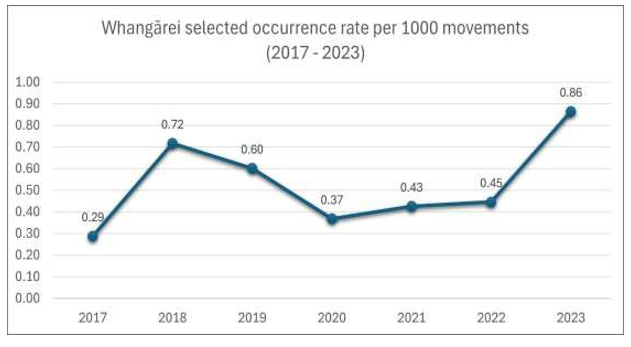
Appendix 9. Whangārei Aerodrome movements
A9.1 This data was extracted from the CAA website occurrence database using the public dashboard interface.
A9.2 This data shows that movements at Whangārei are about 3000 IFR flights and 9000 VFR flights each year. There is a slight trend upwards for VFR, but IFR have remained reasonable steady.
A9.3 The VFR and IFR data do not distinguish what is different between IFR and VFR flights, or what difference that makes at this aerodrome. The aerodrome is uncontrolled and surrounded by an MBZ. All IFR procedures still require visual separation in uncontrolled airspace. So, in this instance, total flight movements are a more reliable parameter to make a comparison of traffic density.